admin

Sep 292020
 

Photo courtesy of Osage Fire Protection District. They’re not only intrepid first responders but excellent photographers. Great picture!

News stories Sept 27 told of three people rescued by the Osage Fire Protection District when their pontoon boat got stuck in the fast current of Lock. Jefferson City firefighters “built a rope rescue system, lowered a rescuer to the boat, and brought the occupants up one at a time.” No one was injured but the KJLU online post by Lesley Taylor noted that in 2009 a man on a jet ski drowned trying to go through the ruined lock.

Other concrete blockages of the Osage River—Bagnell Dam, Truman Dam—have unsavory histories and underperform, but they do serve some contemporary needs like recreation. The ruined 1906 lock and dam on the lower reaches serves no purpose—and never did. It’s a menace to navigation, blocks migratory fish, and every few years kills someone.

In 2012 a long summer drought dropped the river level, exposing the crumbling concrete shell, rusting rebar, and rotten timbers that lurk below the surface and twist the currents of the Osage. We climbed down into the riverbed, walking over and along its ruins. Taking pictures and looking at “the decay of that colossal wreck,” we pondered at the folly of it still being there. We have an extensive post with pictures on the lock, its history and many problems.

We extensively covered it in Damming the Osage: The Conflicted Story of Lake of the Ozarks and Truman Reservoir. The $35, 304-page, all color book, incidentally, we are currently offering for half price, $17.50 postage paid. To purchase, click here.

Apr 262017
 

We’re consolidating our blogs into one platform on Lens & Pen Press (the parent platform if you will) where we will continue to discuss our books–the Beautiful and Enduring Ozarks, the James Fork of the White (coming 2017), Mystery of the Irish Wilderness and See the Ozarks–and many other favorite topics like the Ozarks and water resources. Please join us there!

Damming the Osage blog archive remains available right here! http://www.dammingtheosage.com/the-blog/

and follow us on Facebook and Twitter


COMING IN 2017: JAMES FORK OF THE WHITE: Transformation of an Ozark River.

Sample pages from this new book can be seen at www.beautifulozarks.com

Our earlier ‘river book,’ DAMMING THE OSAGE, can be seen at www.dammingtheosage.com

Mar 192017
 

Josh Rouse writes a detailed examination of the status of #paddlefish reproduction and management in #Kansas, #Oklahoma, and #Missouri. The #Marais_des_Cygnes River in Kansas is the upper reaches of the #Osage_River of Missouri (see Damming the Osage for the story of why the name changes at the state line).

Neely offered Grand Lake in Oklahoma as an example of a highly productive system. He said paddlefish grow faster in that body of water than almost anywhere else in the world because of the high availability of food.

“It boggles my mind how a fish can get up to 100 pounds and never eat anything that you can see with a naked eye,” Neely said. “It’s just really neat how they can do it.”

Feb 152017
 

Jimmy Capps posted on Facebook this lyrical music video account of generations of  his family and their life along the Osage River  since the early 1800s. Acoustic guitar and a haunting harmonica provide a simple but appropriate accompaniment to his original composition. (This is my own transcription from the video. My apologies if there are mistakes!)

Osage River Water

My people came from Tennessee in 1821,
Capps Landing on the Osage is where they made their home.
Great granddad moved to Proctor
When a ferry crossed the stream.
The sons worked the freight boats
burning wood for steam.
Floating ties down the Osage,
Trapping furs and running lines,
Fought the flu and smallpox,
The flood of ‘29

That Osage River water’s flowing in my veins
From the great Wah-Zha-Zhe and everyone between

Granddad lived in a houseboat.
Depression’s scrounged the land.
Moonshine boats, midnight floats, the lawman close at hand
My daddy fished the big lake that stops at Bagnell Dam.
Sold his fish in the town from the trunk of his sedan.
My brothers and I followed suit ‘til we all left the …
Our sons all fish in bass boats and throw away their catch.

That Osage River water’s flowing in our veins
From the mighty Wah-Zha-Zhe and everyone between

Now 30-foot go-fast boats, they scream across the lake
They leave the boats of the country folks a-rockin’ in their wake

That Osage River water’s flowing in my veins
From the mighty Wah-Zha-Zhe and everyone between

Jan 282017
 

When we published this photograph of Osage Chief Red Eagle’s Wife and Daughter we speculated that the Chief referred to was Paul Red Eagle. Recently Michael Snyder, author of a soon-to-be-released biography of John Joseph Mathews set us straight.

Mathews’ account of the funeral of Red Eagle, which we quoted, described final ceremonies, not for Paul Red Eagle (as we speculated), but for “Chief Henry Red Eagle, who served as tribal councilman twice, and was the assistant principal chief from 1910-1912, when John Joseph’s father, William, was on the tribal council.” Paul Red Eagle, per Mr. Snyder, was the son whose lament so moved Mathews.

We thank Mr. Snyder for this clarification and look forward to the publication in May of John Joseph Mathews: Life of an Osage Writer

You can find Mr. Snyder on Facebook at http://facebook.com/MichaelSnyderOK


Aug 052016
 

Recently we finished researching the proposed and controversial Army Corps of Engineers County Line Dam for our upcoming book on the James River. This 1970s dam would have created a 14,000 acre multipurpose reservoir on the James, ten miles east of Springfield.  The entire lake would have been in Webster County, but one end of the dam would have been just a few hundred yards from the Greene County line. One of its multi-purposes was to supply the city with water. A combination of landowner ire, environmentalist objections, and a poor benefit/cost ratio killed the project. During the turmoil the city made other plans for future water needs.

A recent Sunday afternoon, we set out to Webster County to survey the countryside that would have been inundated by that project. The upper James is quite an attractive stream but there is virtually no public access. The creeks that flow into it are typically chert-floored, crystal clear Ozarkian streams. Some have access where roads cross them. DSC_2393-v2 blog

On the second bridge up from the James on Panther Creek, we encountered Patrick Mureithi and his family enjoying an afternoon of wading, swimming and hanging out on the gravel bar.  We chatted in the waning light of early evening, learning that Patrick, a native of Kenya, had lived in Springfield for many years and is a quite well known documentary filmmaker and musician. (http://www.patrickmureithi.com ) We told him of our ‘river books’ (Damming the Osage and work-in-progress James Fork of the White).  He told us he had just written and recorded a song named Riverbed. Coincidence? Or merely our good fortune? Riverbed is a haunting, lyrical song with a ukelele accompaniment, recorded  not in a studio, but in a backyard, with amazing clarity. The lyrics seem so appropriate to our Ozarks hills and streams. You can watch it on YouTube:

https://youtu.be/s0IqsWATHUo

Hold this firm from evening to morning
Though may tribulation come your way
In the hills is where you’ll find your power
Among the trees and riverbed I say

We agreed that these restorative little creeks are ideal places for family outings. We told him where they could access Panther Creek closer to the James, with a little deeper water. If County Line Dam had been built, both these appealing spots would have been deep under the water of the lake

DSC_2381-v2 blog

You can see sample pages of James Fork of the White on our website www.beautifulozarks.com

Follow Lens & Pen Press on Twitter and like us on Facebook.

Jul 262016
 

sc431

Tower Ha Ha Tonka, Mo. “8 miles of L.C.” (probably Linn Creek)
By G. A. Moulder, Linn Creek, Mo. Unsent.

Stone Water Tower, 80 feet high, at Robert M. Snyder’s castle retreat above the Osage River.  Water was pumped from the spring far below to a tank at the top of the tower. Besides holding the water tank above the house and grounds to facilitate gravity feed to supply the water system of the castle.

This tower once held living quarters as well as a water tank at the top of the tower. Historical marker at the park says, “The first four floors were living quarters for the caretaker’s family. A large steel tank on the fifth floor held water for the estate. It’s (sic) interior burned by vandals in 1976. It was reroofed and stabilized in 1999.”‘

G. A. Moulder seems to have been a prolific professional photographer in Linn Creek in the pre-Bagnell Dam era.  While we have not identified details of his life, he did come from an established and well-respected family in Camden County. In 1896, J. W. Vincent, editor of the Linn Creek Reveille, published a series of articles based on accounts from early settlers primarily in Camden and Morgan counties.  Of the Moulder family he wrote:

The Moulder family, since the most numerous and prominent in the county, first arrived in 1837. Judge G. W. Moulder, the first of these, came to Lincoln county in 1830, and to Camden (then Pulaski) in the year named, buying a farm on the Niangua, eight miles above Linn Creek, where he lived nearly fifty years, and died in 1886.

He was one of a family of twelve children, and was afterwards joined by three brothers, Valentine, Silas and Rufus, and by two sisters, Rebecca Capps and Elizabeth Doyle, the latter of whom is still living, on Prairie Hollow, the only surviving member of her father’s family. Judge Moulder had six sons, William G., John B., A. F., Joseph C., V. P., and T. H. B., all of whom served their country during the late war.

Be sure to like Lens & Pen Press on Facebook 

And follow Lens & Pen.Press on twitter


Jul 212016
 

sc427Fishing Camp, Arnolds (sic) Mill, Mo. No. 1176

Arnhold’s Mill was a commercial mill site certainly, but also an early fishing camp/resort on the Niangua River in Camden County not far from Ha Ha Tonka’s springs. In 1896, J. W. (Joshua Williams) Vincent, editor of the Linn Creek Reveille, published a history of Camden County  he had compiled by interviewing early settlers. In it he stated: “The Arnhold Mill, probably the most noted in the county, was founded in 1833 by a man named Kieth.” George and Dorotha Arnhold bought  what by then was called Cleman Mill in 1878. Its scenic location, abundant game, good fishing and congenial owners attracted sportsmen from across the state. Eventually, cabins were built on the nearby hills to accommodate visitors who showed up in season. It was a family-friendly resort as evidenced by the women and child in this photo.

The camping families in this photograph are not identified, but on newspapers.com we found several accounts of visits to Arnhold’s Mill. One story in the May 27, 1915, Index of Hermitage, Mo. could be the caption for this photo:

A party consisting of Dr. A. H. Brookshire and wife, W. D. Harryman and wife, J. W. Powell and Henry Emmett of Wheatland, W. C. Farmer of Collins, J. H. Morgan and family, J. K. Moore and family, J. W. Robertson, Chas. Manuel, C. M. Bentley, S. S. Anderson and Ray Creed of Hermitage, left here Monday for Arnholt’s mill, Camden County, where they will spend a week fishing, hunting, camping out, and having a good time generally.

A couple of other stories came to light as well. The Index, Hermitage, Mo, May 6, 1897, remarked on the weekend fishing trip of Squire E. R. Calkins to Arnhold’s mill where he gained some weight. “He claims fish is the greatest brain food a man can eat.” The Morgan County Republican (July 18, 1907) noted that  Perry L. Gold and Joe Gold of Pittsburgh, Pa., and Loyd and Clarence Lumpe and Charles Moser of Versailles, Mo., spent a week at the mill returning with a 31-pound catfish.

See our earlier post for more about the tribute sportsmen erected for the Arnholds. The site of Arnhold’s Mill is now under the waters of Lake of the Ozarks.

Little record remains of early sporting activities on the Osage River, but that doesn’t mean the area wasn’t utilized. These real photo postcards provide scarce evidence of those days. No identification on the card of the photographer or where it was published.


Jul 172016
 

sc428

Webster bluff – Hahatonka
Jas. Bruin. Linn Creek. Mo. Unsent.

The caption on this vintage image seems to indicate that at one time Webster Bluff may have been part of  large holdings of the Snyder family, known as Ha Ha Tonka. A Karst masterpiece of the Ozarks, Ha Ha Tonka – a more dramatic complex of collapsed cave, sinkholes, cliffs than any similar area – fascinated not only wealthy Kansas Citians like the Snyders, whose estate encompassed 5,400 acres but local people as well. And it still does. Ha Ha Tonka is an extremely well-attended state park today, southwest of Camdenton.

This idyllic scene could be recreated today. Google “Webster Bluff”  and you’ll find it’s located in northeast Dallas County in the Lead Mine Conservation Area, which lies about halfway between Camdenton and Buffalo.  You can fish, float, hike and commune with nature at Webster Bluff still.  More than two miles of the Niangua River flow through the almost 8,000 acres of Lead Mine as well as 3.5 miles of Jakes Creek. The Missouri Department of Conservation identifies its highlights:

This forested area contains savanna, glades, and old fields. Facilities and features include boat ramps, an unmanned firearms range, fishable ponds, several intermittent streams, and two permanent streams (Niangua River, Jakes Creek). . . . Lead Mine Conservation Area contains many excellent examples of dolomite glade communities, oak-hickory uplands, and clear running springs.

One of those springs is named Webster as well.

Jul 132016
 

sc426

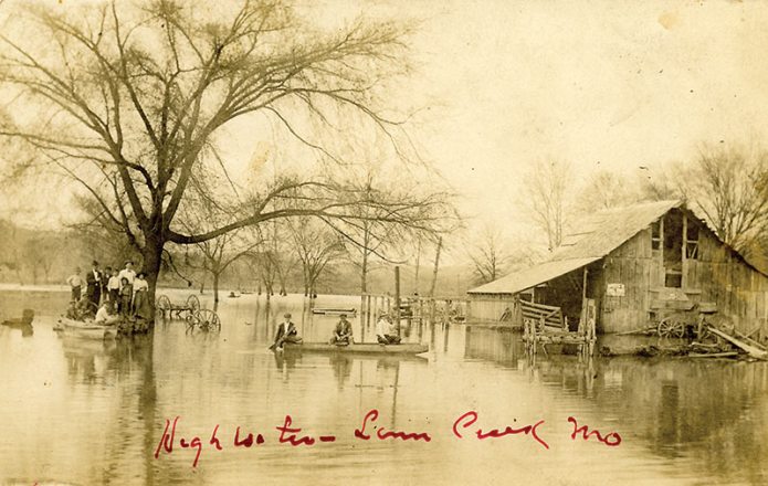
High Water Linn Creek Mo.
Real Photo Postcard by J. W. Farmer, Linn Creek, Mo. probably around 1920. Unsent.

The Osage could play havoc with your plans. Flooding was a regular event in Linn Creek but it didn’t seem to deter people from living there.  Floods were a dramatic and photogenic affair. Even today, a flood brings out the photographers. An obvious question comes to mind: what piece of dry ground was the photographer standing on? Perhaps he was precariously perched on another boat? It’s a great image of a watery world. Hardly a square foot of terra firma is showing!
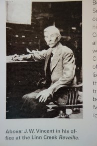
JWVincent-p104


We’ve posted a number of flood scenes of Linn Creek on this blog.  Perhaps several were of a single event, but Linn Creek was hit with rising waters more than once. Despite fairly frequent incursions of the Osage into the town’s streets and homes, the editor of the city newspaper,  The Reveille, railed against building Bagnell Dam.  J.W.)Vincent understood full well that occasional spring rises were better for the community than permanent inundation of their homes and the most productive land of the river bottoms.


This photo (of a photo) of Joshua Williams (J.W.) Vincent is from page 104 in Damming the Osage. The caption reads:

Before coming to Missouri in 1866, J. W. Vincent’s father, J. S., had worked for Horace Greeley, fought in the Mexican War, been wounded twice by Indians, dug for gold in California, and married an Irish girl in Milwaukee. An 1889 county history classified the newspaper he founded as a “spicy journal in the interests of the Republican Party.” The son (J. W. ) bought the Reveille from his father in 1880 and edited it until his death in 1933.